

Maps
As part of crafting their narratives concerning past events, historians utilize images—portraiture and photographs. Most importantly, they work up maps: political, military, demographic, and economic maps that capture the kinds of changes history studies. In support of telling America’s story, one film at a time, our team is building out a bank of maps arranged in chronological order, beginning with the Great Migration of Euro-Asians to North America and extending into recent events in American history.
Chronology of Events in Maps:
Pre-1492 Migratory routes of first humans into North America, plus archaeological evidence of early human settlements in North America.
1375 Catalan Atlas, made by Abraham Cresques.
1489 Map of the known world that Columbus would have used; interactive map of four Columbus voyages to New World.
1501 Amerigo Vespucci (“America”) voyages to Brazil, first to realize continental America.
1507 Waldseemüller map, first to use the name America.
1513 Juan Ponce de León voyage to Florida.
1519 Álvarez de Pineda map of Texas coastline.
1521 Ferdinand Magellan voyage around South America into the Pacific, circumnavigates the globe.
1524 Giovanni de Verrazzano exploration of American east coast.
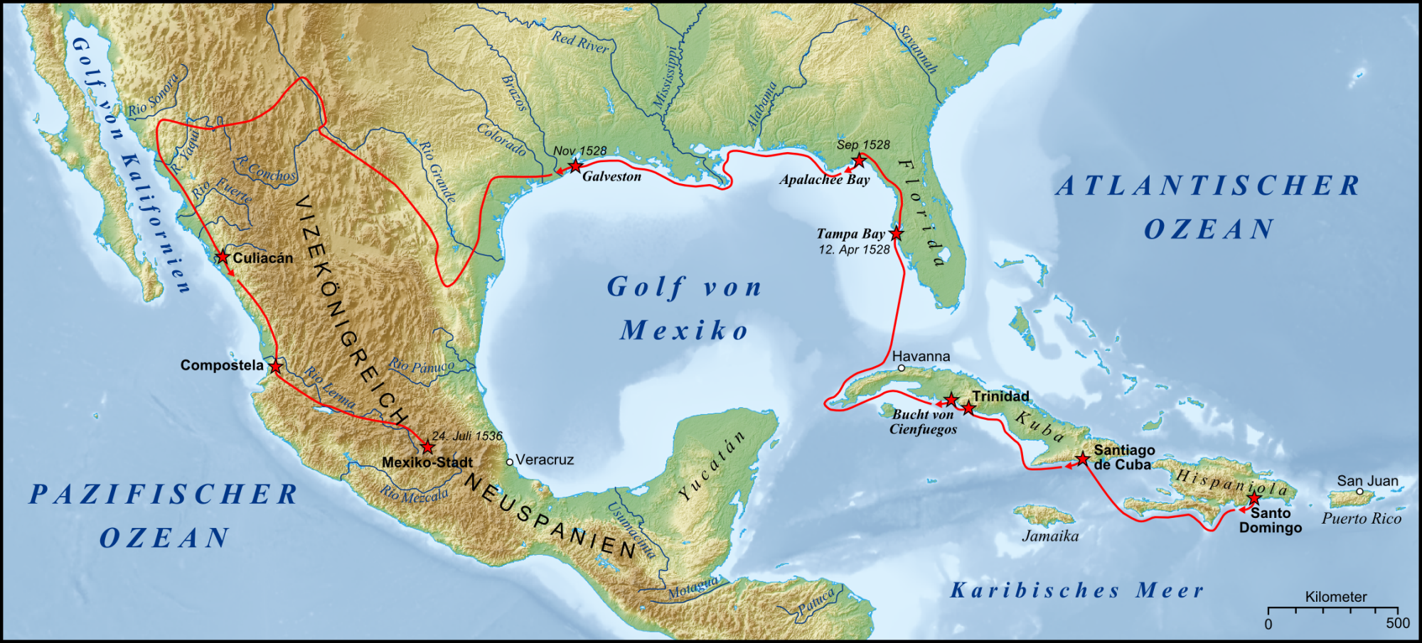
1534–1536 Álvar Núñez Cabeza de Vaca, exploration from Florida to the Gulf of California.
1539–1542 Hernando de Soto (1500–1542) explores Florida, Georgia, and Alabama, crosses the Mississippi River.
1540–1542 Francisco Vásquez de Coronado explores territories from Arizona to Kansas.
1542 Juan Rodriguez Cabrillo navigates the California Coast.
1584 Walter Raleigh lands on Roanoke Island; calls the land, Virginia.
1607 Jamestown settled.
.png)
1620-1691 Plymouth Colony developed.
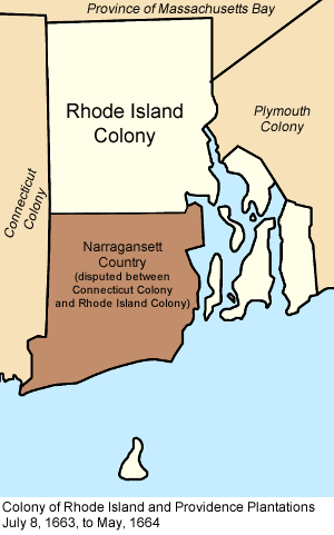
1663 Rhode Island established.
1650-1860 Map of the Transatlantic Slave Trade.
1670 Map likely used to determine boundaries of colonial Maryland.
1681 Pennsylvania established; disputes over land claims last for a century.
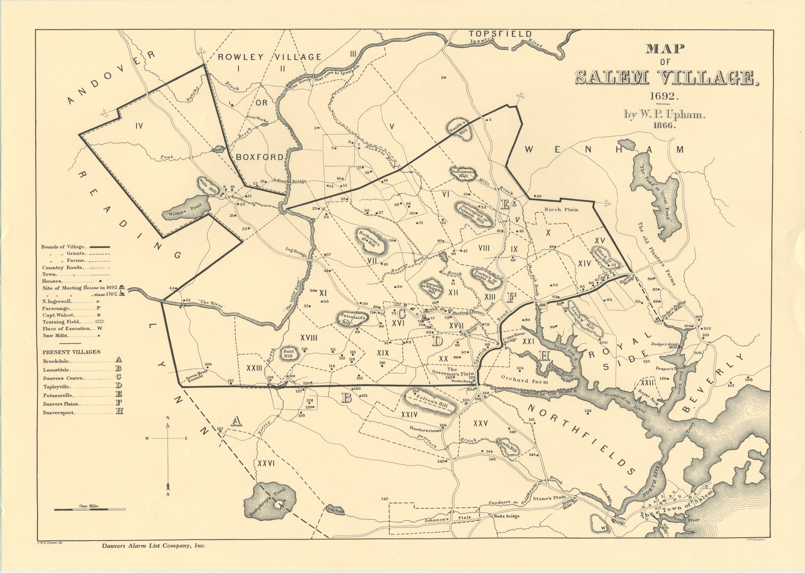
1692 Witch trials conducted in Salem.
1746 French Map of North America, highlighting the English, French, and Spanish territories.
1750 European colonies in North America on the eve of the French and Indian War.
1754-1760 Major battles fought in French and Indian War.
1763 Treaty of Paris determined European holdings in American colonies.
1763 Map of King George III’s Royal Proclamation Line.
1770 Paul Revere’s map/plan of the Boston Massacre.
1773 Map of Boston around the time of the Boston Tea Party; map of the route taken from meeting house to the wharf.
1774 Map of the Thirteen Original American Colonies.
1775 Map of Boston and Vicinity: Lexington and Concord, Initial Dispositions and Movements, 19 April.
1775 Plan of Boston map.
1775 Map of the Battle of Bunker Hill.
1775 Map of the Knox Trail between Boston and Fort Ticonderoga.
1776 Battle map of Trenton with battle overview data.
1777 Saratoga Campaign; the events leading up to, during, and after the Battles of Saratoga.
1778 A new Map of North America: from latest discoveries.
1779 Map of Battle of Flamborough with brief narrative.
1781 Map of Battle of Cowpens.
1781 Map of Battle of Guilford Courthouse, with brief narrative, data graph, and Lines 1, 2, and 3 maps of the Battle.
1781 Siege of Yorktown narrative and data graph.
1781 Map of Hamilton’s Assaults on Redoubts 9 and 10, with narrative and data graph.
1783 The Treaty of Paris ended the American Revolution and formally recognized the United States as an independent nation.
1783-1863 Map showing the “Routes of the Underground Railroad” to Canada.
1787 Map of the Northwest Territory, established by the Northwest Ordinance.
1795 Map of Pinckney’s Treaty, secured navigation rights to the Mississippi and established the southern boundary of the United States.
1795-1803 Map of Indiana and Michigan territories with dated land cessions.
1795-1840 A Map of Indiana showing the areas purchased, dates, and the name of the treaties. The land was purchased from Native Americans
1796 Map showing the naval encounters between France and the United States during the Quasi War.
1796 Electoral Map (Election of 1796).
1800 Electoral Map (Election of 1800).
1800 Map of the United States.
1800 Map of the Indian Tribes of North America along the Atlantic.
1800 “A new map of the world,” showing both hemispheres.
1803 Map showing the Louisiana Purchase with present-day states outlined.
1803 Map showing the Louisiana Purchase without states.
1803 Map of States and Territories of the United States of America from April 1803 to March 1804.
1804-1806 Map of the Lewis and Clark Expedition Route.
1806 Map of the Western Hemisphere.
_-_Geographicus_-_America-cary-1806.jpg)
1808-1825 Animated Map of Spanish control in the Western Hemisphere.
1811 Map of the Battle of Tippecanoe.
1812 U.S. Forts in 1812.
1812-1814 War of 1812 Battle Map (Northern Theatre), including Detroit Region, Chesapeake Region.
1812-1815 War of 1812 major battles map.
1813 Map of the Battle of the Thames.
1814 Map of the Battle of Lundy’s Lane.
1814 British Land and Sea Advance on Washington in August 1814.
1814 Map of the Bombardment of Fort McHenry.
1814 (publication date) Map of Lewis and Clark's Track, 1804-1806, cross the Western Portion of North America. Created by Meriweather Lewis.
1815 Map the British Advancement on New Orleans (22 November, 1814 - 11 February, 1815) and the Battle of New Orleans.
1819 Map of the Adams-Onís Treaty in which Spain ceded Florida to the United States.
1820 Map of the Missouri Compromise.
1823 Map of the United States.
1824-1836 Map of the United Mexican States.
1824 Electoral Map (Election of 1824).
1825-1830 Map of the United States.
1828 Electoral Map (Election of 1828).
1830 Map of the Indian Removal Act.
1830 Map of the United States and Canada, with part of the Mexican states.
1830-1839 Map of the Five Civilized Tribes and their relocation to Indian Territory (present-day Oklahoma).
1835 Battle of Gonzales map, showing the ‘first shot’ of the Texas Revolution (scrolling required).
1835 La Bahia Mission layout, where the Battle of Goliad took place.
1835 Map of the Battle of Concepcion.
1835 Map of the Siege of Bejar.
1836 Map of the Texas Revolution, including General Santa Anna’s march to San Antonio de Bejar (scrolling required).
1836 Map of the Battle of the Alamo (scrolling required) and mission layout.
1836 Map of the Battle of Coleto Creek.
1836 Map of Battle of San Jacinto.
1836 Map of the Republic of Texas, detailed from Lizar’s Map of Mexico and Guatemala.
1837-1839 ‘Trail of Tears’ Route Map.
1840 Electoral Map (Election of 1840).
1841 Map of the Wilkes’ Expedition through the Oregon Territory.
1843 James C. Fremont’s original expedition map of the “Oregon Trail.”
1846 Map of the Battle of Palo Alto, near the site of the Thornton Affair.
1846 Map of the Oregon Treaty.
1846-1847 Map of the Northern Campaign of the Mexican-American War, including the Battle and Siege of Monterrey.
1847 General Winfield Scott’s Campaign of the Mexican-American War, including the Siege of Veracruz, the Battle of Mexico City, and detail from the Battle at Chapultepec.
1848 Map of territory given up by Mexico to the United States by way of the Mexican Cession.
1848 Map of the United States after the Treaty of Guadalupe Hidalgo.
1849 Map of the gold regions and mining districts of California.
1850 Detailed Map of California, showing Sacramento, Suttersville, and the location of Sutter’s mill.
1850 Map of the United States.
1850 Map of the Oregon Trail.
1855 Map of The Kansas and Nebraska Territories.
1855-1865 Civil War on the Western Border, including massacre and skirmish locations from The Missouri-Kansas Conflict or “Bleeding Kansas.”
1859 Route Map of John Brown’s Raid on Harper’s Ferry.
1859 Map of Harper’s Ferry as it appeared in 1859 at the time of John Brown’s Raid, including detail of Downtown Harper’s Ferry.
1860 Electoral Map (Election of 1860).
1860-1861 Map of the Secession Crisis from 1860 to 1861 (with dates).
1861 Map of the United States, including Kansas as well as states seceded from the Union.
1861-1865 Map of the United States, highlighting the boundary between Union and the Confederacy.
1861-1865 Map of the Confederate States of America, including dates of secession.
1861 Map of Charleston Harbor, including the firing upon the Star of the West and the Battle of Fort Sumter.
1861 Map of the Battle of First Manassas (July 21, 1861), including Johnston’s movement from Shenandoah Valley, July 18, 1861, morning, afternoon, evening.
_July_18.png)
_July_21_1000.png)
_July_21_1300.png)
_July_21_1600.png)
1861 Map of the Battle of Hatteras Inlet Batteries (August 28-29, 1861).
1861 Map of the Battle of Ball’s Bluff (October 21, 1861).
1862 Maps from the Battle of Mills Springs (January 19-20, 1862): Moulden’s Hill, Logan’s Crossroads.
1862 Map of the Battle of Fort Henry (February 6, 1862), Battle of Fort Donalson (February 15, 1862), and Battle of Island No. 10 (February 28-April 8, 1862).
1862 Maps from the Battle of Pea Ridge (March 7-8, 1862): Leetown, Elkhorn Tavern Mar. 7, Elkhorn Tavern Mar. 8.
1862 Maps from the Battle of Hampton Roads (March 8-9, 1862): March 8, March 9.
1862 Maps from the Battle of Shiloh (April 6-7, 1862): 10am-noon, noon-4:30pm, 5pm-7pm, Day 2).
1862 Map of the Capture of New Orleans (April 25-May 1, 1862): Maps of Forts Jackson and St. Phillip.
1862 Map of the Siege and Battle of Corinth (April 29-October 4, 1862).
1862 Map of the Battle of Williamsburg (May 5, 1862).
1862 Maps from the Battle of Seven Pines (May 31-June 1, 1862): May 31, June 1.
1862 The Seven Days Battles (June 25-July 1, 1862): Oak Grove (June 25), Mechanicsville (June 26), Gaines’ Mill (June 27), Garnett’s Farm (June 28), Savage’s Station (June 29), Glendale (June 30), Malvern Hill (July 1).
1862 Maps from the Battle of Second Manassas (August 28-30, 1862): Brawner’s Farm, August 29 - 8am to 10am, August 29 - 4:00-6:00 pm, August 30 - 3pm, Chinn Ridge.
1862 Map of General Robert E. Lee’s Maryland Campaign.
1862 Map of the Siege of Harper’s Ferry (September 13-15, 1862).
1862 Map of the Battle at Fox’s and Turner’s Gap (September 14, 1862).
1862 Maps from the Battle of Antietam (September 17, 1862): West Woods - Morning, Sunken Road, Burnside’s Bridge.
1862 Map showing Union and Confederate movements during the Fredericksburg Campaign.
1862 Maps from the Battle of Fredericksburg (December 11-15, 1862): Dec. 11 - Urban Combat, Dec. 13 - Overview, Dec. 13 - Marye’s Heights, Dec. 13 - Hamilton’s Crossing.
1862-1863 Map overview of the Vicksburg Campaign (December 26-July 4, 1863): December 1862-April 1863, April-July 1863, May 25-July 4, 1863).
1863 Map of Union General Joseph Hooker’s Plan for the Chancellorsville Campaign.
1863 Maps from the Battle of Chancellorsville (April 30-May 5, 1863) Hooker’s Flank March, Zoan Church, Jackson’s Flank Attack, May 3 - Hazel Grove, May 4 - Union Retreat and a map of the Second Battle of Fredericksburg (May 3, 1863).
1863 Maps of battles from the Vicksburg Campaign: Siege of Jackson (May 10-17, 1863), Battle of Champion Hill (May 16, 1863), Battle of Big Black River Bridge (May 17, 1863).
1863 Map of the Robert E. Lee’s Gettysburg Campaign, including Battle of Brandy Station (June 9, 1863).
1863 Maps from the Battle of Gettysburg (July 1-3, 1863): Day 1, Day 2, Day 3, July 3 - Pickett's Charge.
1863 Map of Lee’s Retreat after the Confederate loss at Gettysburg (July 4-16, 1863).
1863 Maps from the Battle of Chickamauga Creek (Sept. 18-20, 1863; scroll down for hour by hour maps from the different days of battle).
1863 Maps from the Siege of Chattanooga (Sept -Nov. 1863): Union Retreat to Chattanooga, Wheeler’s Raid, Grant’s Cracker Line.
1863 Maps from the Battle for Chattanooga (Nov. 24-25, 1863): Overview, Missionary Ridge, Tunnel Hill.
1864 Map of the Overland Campaign (May-June 1864).
1864 Maps from the Battle of the Wilderness (May 5-6, 1864): May 5 - Orange Turnpike, May 6 - Orange Turnpike, May 6 - Orange Plank Road, various troop movements.
1864 Maps from the Battle of Spotsylvania (May 8-21, 1864).
1864 Maps from the Battle of Cold Harbor (May 31-June 12, 1864) : June 1, June 3.
1864 Map of the Atlanta Campaign (May 7-September 1, 1864): Battle of Kennesaw Mountain (June 27, 1864) Battle of Peachtree Creek (July 20, 1864), Battle of Atlanta (July 22, 1864), Battle of Ezra Church (July 28, 1864).
1864 Maps of General Sherman’s “March to the Sea.”
1864 Map of the Siege of Richmond, Union and Confederate positions in Fall of 1864.
1864 Electoral Map (Election of 1864).
1888 Map of Indian Territory (present-day Oklahoma), featuring the lands of the Cherokee, Chickasaw, Choctaw, Creeks, and Seminole nations.
1904 Map of Central America.
2008 CIA map of Central America and the Caribbean, including Cuba.
1790-present United States Historical Map, this timeline map attempts to show all border changes for the states from 1790 to today.
Maps will be added to this bank chronologically as we progress through history with the films